|
| |
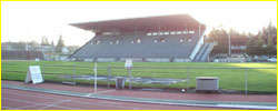
Hayward Field Info
Facilities,
Events and Operations website for Hayward Field
Tracktown,
USA Info
Running Area Map - Oregon
Track Club
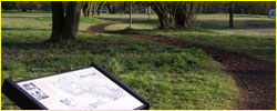
The map was designed by longtime OTC member Larry Norris coordinated
the services of two local companies to produce a runner's map
for residents of the Eugene-Springfield and vicinity, as well
as visitors to this area. The donated efforts of Jim Reed and
Mike Renslow of Image Mapping, along with free printing of the
first 5000 copies by QSL Printing, has resulted in a beautiful
and useful color map which highlights all the trails, paths and
tracks suitable for running.
Free maps and brochures of this info are available at the following
area locations:
:: Convention & Visitors Association
of Lane County Oregon (CVALCO), 115 W. 8th St. Eugene
:: Eugene Chamber of Commerce, 1401
Willamette St. Eugene
:: Springfield Chamber of Commerce,
101 S. A St. Springfield
:: Run Pro, 525 High Street Eugene
:: Nike Store, 5th St. Marketplace
Eugene
:: Copeland's Sports, 245 Valley
River Center Eugene
:: Big 5 Sporting Goods, 2720 Gateway
St. Springfield
:: Eugene-Springfield area hotels
and motels
|
| |
Amazon Trail
Location:: South Eugene, bordered
by Amazon Parkway and Hilyard Street. Parking is available at the
corner of 24th and Amazon Parkway.
Grade::
Flat
Length:: 600 meters-1 mile
loop
Footing:: Soft woodchip trail,
approximately 8-12 feet wide.
Description::
The other well-known trail in town, located next to Roosevelt Middle
School. There's a 600-meter, 1,000-meter loop and 1-mile loop, all
configured in a figure eight with a grove of trees in the middle
and the Amazon River on one edge. All the local track legends workout
here, sharing it with a wide mix of walkers and joggers of all ages.
The loop is entirely flat, and its width can accommodate groups
of runners 4-5 wide. The wood chip surface is one of the softest
runs you'll find in town and is well-maintained.
|
| |
Hendricks Park
Location:: South Eugene, 5 access
points on Spring Blvd (far eastern), Dillard Road, Fox Hollow
Road, Willamette Street and Loraine Highway (far western)
Grade:: Moderate to Steep
Length:: Various, up to 11 miles
Footing:: Dirt singletrack, some
gravel, also wide, aromatic horse trails.
Description:: This beautiful city
park offers something for all ages, although it's only open to
those on foot. A network of singletrack, fine-gravel trails and
paved paths connect through a Rhododendron garden, camping and
picnic area, with several ways to access the area. Key roads to
the top of this hilly section of southeast Eugene are Riverview,
Fairmont, Cresta del Ruita, Capital Avenue, Heights and Summit
Avenue. All of them trace up windy roads and empty out at various
points of the park (but all are within a mile of each other),
with Fairmount and Cresta del Ruita the only roads to the top.
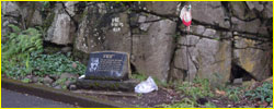
Look for Pre's Rock -- a memorial to the Oregon distance-running
star Steve Prefontaine who died in a nearby car crash in 1975
near the corner of Birch Street and Skyline Boulevard -- when
you're near the Rhododendron Gardens. Also keep an eye out for
many of the city's most unique houses in this area.
Directions:: Following Birch Street,
a block south from the corner of 15th and Fairmont, driving up
the steep hill for approximately a mile is the easiest way to
find Hendricks Park, but you can also find it off of Fairmont
Street which curls around the butte just to the west. There are
several other roads that end at various points to the top. Historic
Hayward Field, the premier track and field-only facility in the
nation, is located 1 1/2 miles from Pre's Rock at the corner of
15th Avenue and Agate Street. |
| |
Rexius Trail
Location::
South Eugene, bordered by East and West Amazon Parkway roads, just
south of junction of 34th street. No specific parking area but parking
is permitted along the street.
Grade::
Flat
Length:: 2-3 miles
Footing::
Soft, woodchip trail, approximately 6-8 feet wide.
Description::
An easy-to-find wood chip trail great for a morning jog, especially
since it connects to the Amazon Trail near 30th Street. It runs
along both sides of the banks of the Amazon Creek and is an easy
add-on to the Amazon Trail run.
|
| |
Ridgeline Trail
Location::
South Eugene, 5 access points on Spring Blvd (far eastern), Dillard
Road, Fox Hollow Road, Willamette Street and Crestview Street (far
western), connecting Southridge, Spencer Butte, East Spencer Butte
and Hult Parks.
Grade:: Moderate-Steep
Length:: 1,200 meters-1 mile
Footing::
Dirt singletrack
Description::
One of the outdoor treasures of the Eugene area -- nearby to town
but also scenic enough that you forget about the proximity. If you
choose to jog, the grade is hilly, but the lush fauna and forested
setting obscures how high (and low) some of the hills really are.
In the fall, the changing leaves make this one of the most visually
exciting hikes around, and you can even take an off-shoot (another
1.5-2 miles long) to the top of Spencer's Butte for one of the best
views from above of Eugene. The best way to get to the trail is
to drive to the several access points from any of the four roads
(except Spring Street which dead-ends at the trail head) that split
the trail up -- each parking lot has room for 6-12 cars so there's
almost always open spots. All four lie at the south edge of town
near the city limits in the 60th Avenue vicinity (if there was such
a road). The trail is marked at each trailhead and it's never more
than 2-3 miles before you cross each of the intersecting roads,
while the overall length from one edge to the other is approximately
6-7 miles.
Directions: Take any of the above-mentioned roads (Fox Hollow, Dillard,
Willamette, Crewstview) south from the southern edge of town and
all are with 1-2 miles of the city limits with signs indicating
the parking areas and trailheads.
|
| |
Powerlines
Location::
South Eugene, accessible from the corner of Western Amazon Parkway
and Martin Street
Grade:: Moderately
uphill
Length:: Various, up to
3 miles (out-back or more if connecting to Ridgeline Trail).
Footing:: Dirt/muddy singletrack and
doubletrack.
Description:: Mostly
known to only the hardiest of local hikers and trail runners, this
southern Eugene option offers lots steep, rocky hills and sometimes
a fair share of mud. A good access point is at the southern edge
of the Rexius Trail. The trail leads up a wide, gravel, off-road
path then starts branching out for various short options. Take a
left after about 300 meters on a segment leading over a small creek,
and then another left in 200 meters, and this leads you out east
towards Dillard Road with 1-1.5 miles or two-mile ascent (if you
take a right fork) to the Ridgeline.
Directions:
Drive south along the western edge of the Amazon Creek until it
ends at Martin Street where it curls to the left. Park here along
the street next to the white gate, which blocks a gravel road/trail
continuing upwards to the south (trail starts here).
|
| |
Pre's Trail
Location:: Within the city limits
in northern Eugene alongside Alton-Baker Park and the Willamette
River. Parking is accessible in the park near the Ferry Street Bridge,
near the corner of Country Club Road and Centennial Blvd (near Autzen
Stadium). The trail is also accessible by both footbridges: Autzen
Footbridge -- a half block north of the corner of Franklin and Agate
Streets -- and Knickerbocker Footbridge -- near Franklin and Riverview
Streets
Grade:: Flat
Length::
4-6 miles
Footing:: Combination
of dirt singletrack, woodchips and asphalt
Description::
One of the most famous jogging trails in Eugene, running along the
McKenzie River and featuring wood-chip paths that intersect grasslands,
ponds, woods and other lush green areas in the neighborhoods of
campus, Autzen Stadium, and even parts of Springfield. Bikers and
roller-bladers also can share the area on several miles of flat
intersecting concrete/asphalt paths.
|
| |
Skinner's Butte
Location::
Eugene, near the Ferry Street Bridge
Grade::
Moderate
Length:: 1200 meters-1
mile
Footing:: Dirt singletrack,
woodchips at base of butte.
Description::
A moderate, short picturesque hike in northern Eugene. Located within
view of the nearby Ferry Street Bridge on the northern edge of town,
there's a 1-1 1/2 mile road on the south edge of the butte, situated
next to the downtown, that also arrives at the summit. On the northern
edge of the butte, however, a mile-long switchback dirt/wood chip
trail leads to the top on the side facing the river. Nearby along
the river's edge, joggers/bikers/roller-bladers can also trace the
concrete footpaths for several miles away from town. The opposite
direction, these same concrete paths trace the Willamette River
into Alton-Baker Park near the Pre Trails. Parking is located along
Skinner Butte loop which turns into High Street towards downtown.
|
| |
Westmoreland Park
Location::
Jefferson High School, near 21st Avenue and Polk Street in west
Eugene
Grade:: Flat loop
Length::
Approximately 1-1.5 miles of trails/grass
Footing::
Wood-chip trail
Description:: This
area path hosts many high schools cross country races in the fall
and is often less-busy than some of the other more well-known trails.
Directions: Drive west on 18th street to Polk Street, then turn
south for three blocks to 21st Avenue and park anywhere nearby on
the street. |
|
|
For more challenging
adventures,
see a local outfitter store for maps and information on popular
hikes such as Mount Pisgah (5 miles south of Eugene), Goodman
Creek (20 miles south of Eugene), McKenzie Trail (about 50 miles
east of Eugene) and other adventures ranging from coastal settings
to mountainous excursions in the nearby Cascade Mountain range.
Steve Prefontaine Bio & Pix
Oregon
Track Coaching Legends - 'The Three Bills'

::Descriptions
Taken from GoDucks.com
::Thank
you Geoff D Thurner Asst. Dir, Media Services , UNIVERSTIY OF
OREGON
|
|